
Description
Ordnance Survey Somerset, Wiltshire & the Mendips – Pathfinder Guide 21
Outstanding Circular Walks – 1:25,000 Scale
175 miles of super walking contrasts: from the heart of the Somerset Levels at Langport to the Great Natural Wonder of Cheddar Gorge in the Mendip Hills.
Take a journey on 28 beautiful walks exploring Somerset, Wiltshire, & the Mendips, with the OS Pathfinder Guidebooks, graded by length and ranging from 3 ½ to 10 miles.
Make the most out of your next trip! This guide includes two of the most beautiful and historical counties in Britain, Somerset & Wiltshire. Ranging from the breezy heights of the Mendips to the flat meadows of the Somerset levels, and everything in between.
Each walk includes easy-to-follow route directions and accompanied by large-scale Ordnance Survey route maps, GPS waypoints, and captivating photographs. Walks in this guide include Avebury, Stonehenge, Glastonbury, Wookey Hole, Cheddar Gorge, and the Uffington White Horse.
This is one of a series of books with great walking routes covering the most popular and scenic areas of Britain. Printed with weather-resistant covers featuring durable rounded corners, they are the perfect companion for country walking throughout Britain.
Walks in this book:
Nunney Combe
Nettlebridge and Harridge Wood
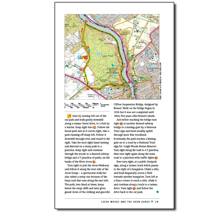
Leigh Woods and the Avon Gorge
Devizes and Caen Hill Locks
Ilminster and Herne Hill
Old and New Wardour Castles
Fovant Down
Axbridge and Cheddar Reservoir
Langport and Muchelney Abbey
Salisbury and Old Sarum
Avebury, West Kennett, and Silbury Hill
Weston Woods and Sand Bay
Lacock and Bowden Park
Uffington Monuments and Vale of the White Horse
Lambourn Downs
Bradford-on-Avon, Westwood, and Avoncliff
Pewsey Downs
Tollard Royal Win Green
Ham Hill, Montacute, and Norton Sub Hamdon
Hinton Charterhouse and Wellow
Glastonbury
Cheddar Gorge
Stonehenge
Cadbury Castle and the Corton Ridge
Barbury Castle and Ogbourne St Andrew
Wells, Ebbor Gorge, and Wookey Hole
Savernake Forest
Burrington Combe, Dolebury Warren, and Black Down
They also contain:
- Ordnance Survey mapping;
- background details of each area;
- details of refreshment stops and parking;
- walking safety advice; and
- information about walkers and the law.