

Description
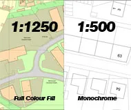
<p><strong>Location & Block Plan Bundle Pack – Emailed PDF Format</strong></p><p>This Bundle is aimed at customers requiring 2 scales of site mapping (1:1250 and 1:500) in order to submit planning applications with their local authority </p><p align=”justify”>This large scale map bundle comprises of 1, 1:1250 scale location map and 1 block plan at 1:500 scale, These files are sent to you by e-mail as a PDF file in a choice of colour fill options.</p><p>**Before purchasing your planning map, please be aware of the differences and uses in the guide below as customised mapping cannot be refunded:</p><p><strong>FORMAT GUIDE:</strong></p><p><strong>PDF</strong> format is the most popular format and provides the mapping extract in a template which includes all licence data and a North compass illustration ready to submit for planning. PDF versions can be supplied as hard copy by post (non vatable), or electronically supplied by email (vatable) and are non editable.</p><p>If you are unsure of the property’s postcode you can check it <a title=”Postcode Checker” href=”http://postcode.royalmail.com/portal/rm/postcodefinder;jsessionid=WRW5F5WTOULRWFB2IGJERWQ?catId=400145&pageId=pcaf_pc_search&_DAV=normal&_DARGS=/portal/rmgroup/apps/templates/html/postcode/oneResult.jsp_A&gear=postcode” target=”_blank”>here</a> </p><p>For larger area coverage, customised digital mapping or further options, please contact our mapping team on 0845 634 62 66 who will be happy to deal with your request.</p><p class=”bodyGrey11″><strong>Scale: </strong></p><p class=”bodyGrey11″><strong>1:500 – </strong>A detailed plan for accurately illustrating proposed works on a propery such as an extension or conservatory. This scale is increasingly requested by Local authorities to be submitted alongside 1:1250 plans.</p><p class=”bodyGrey11″><strong>1:1250 – </strong>The 1:1250 is an industry standard scale and the most commonly used planning extract scale. Due to the properties of this version of data, it enables a good picture of the property and an overview of how it fits within its surrounding area.</p><p class=”bodyBlue14Bold”>Product scales / coverage:</p>A4 size: Scale and Coverage1:500 – 80m x 80m. 1:1250 -<p>200m x 200m</p><p>*Please note mapping coverage for Northern Ireland is not available </p>