
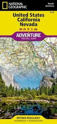


Description
•Approximately 4 1/4″ x 9 1/4″ folded
•25 1/2″ x 37 3/4″ fully opened
•Scale = 1:1,300,000
•Contour Interval = 100 meters
Each title contains accurate topography, up-to-date roads, points-of-interest, and detailed inset maps for major cities, plus a host of important travel tips. Adventure Maps are printed on the same durable, waterproof, and environmentally friendly material as our Trails Illustrated maps, making them ideal for the rigors of international travel.
The United States California and Nevada Adventure Map will guide you through two of the most spectacular and diverse states in the country. California and Nevada contain Yosemite and Sequoia & Kings Canyon National Parks, Death Valley and the Mohave Desert, the Sierra Nevada Mountains, Lake Tahoe, and dozens of magnificent National Monuments, Forests, and Wilderness Areas. The map includes the cities of Los Angeles, San Francisco, San Diego, and Las Vegas as well as the breathtaking Pacific coast of California. It covers western Utah and Arizona, including Grand Canyon National Park and the cities of Phoenix and Salt Lake City. There is simply no better map for exploring California and Nevada.