

Description
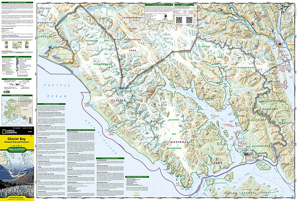
More than just a map, National Geographic Trails Illustrated topographic maps are designed to take you into the wilderness and back. Printed on tear-resistant, waterproof material, this map can go anywhere you do. Each map is based on exact reproductions of USGS topographic map information, updated, customized, and enhanced to meet the unique features of each area. The maps include valuable wilderness tips and Leave No Trace guidelines, along with updated trails, trailheads, points of interest, campgrounds, and much more. With a new color palette and stunning shaded relief, backcountry navigation has never been easier.
Some of the key areas of interest covered include Glacier Bay Wilderness, portions of Tongass National Forest, Chicagof Island, Endicott River Wilderness, Chilkat State Park, Chilkat Islands, Sullivan Island State Marine Park, Pleasant Island, Lemesurier Island, Inian Islands, and Tatshenshini Alsek Park. Waterways include the Gulf of Alaska; Glacier, Tituya, Berners, Tidal, Scidmore, and Taylor bays; Cross Sound; Icy Strait; Lynn Canal; North Passage; and Geikie, Muir, Tarr, Chilkoot, Chilkat, Wachusett, Queen, and Rendu inlets. The print version of this map contains detailed insets of Tarr and Johns Hopkins inlets, Gustavus, and Lamplugh Glacier.Transportation in Glacier Bay’s wilderness can be challenging, but you’ll find the information you need on this map with an accurate road network, ferries, boat ramps, harbors and anchorages, seaplane bases, seaplane anchorages, airports, and landing strips. In addition to contour lines, shaded relief, and summit elevations, this map highlights the many waterways with bathymetry, depths, and navigational aids. A handy distance chart will help you plan your outings. Many recreation features and facilities are noted as well, including hiking trails, campgrounds, picnic areas, rental cabins, lodging, boat fueling stations, ranger stations, and scenic byways. A full UTM grid is printed on the map to aid with GPS navigation.Other features found on this map include: Alsek Glacier, Alsek River, Brady Glacier, Cape Fairweather, Cape Spencer, Carroll Glacier, Casement Glacier, Chilkat Lake, Chilkat Range, Chilkat River, Cross Sound, Endicott River Wilderness, Fairweather Range, Glacier Bay, Glacier Bay National Park, Glacier Bay National Preserve, Grand Plateau Glacier, Icy Point, Icy Strait, Johns Hopkins Inlet, La Chaussee Spit, Muir Glacier, Muir Inlet, Novatak Glacier, Palma Bay, Plateau Glacier, Pleasant Island, Pleasant/Lemusurier/Inian Islands Wilderness, Tarr Inlet, Tongass National Forest.