
Description
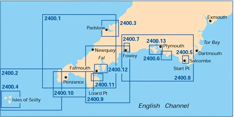
A pack of 16 charts for the West Country. The pack includes:
2400.1 Land’s End to Trevose Head (1: 180 000) includes plans: Newquay Bay, Saint Ives
2400.2 Approaches to the Isles of Scilly (1: 120 000)
2400.3 Isles of Scilly (1: 40 000) includes plan: St Mary’s Road
2400.4 River Camel (1: 30 000) includes plan: Padstow Harbour
2400.5 Salcombe (1: 15 000)
2400.6 River Yealm (1: 12 500)
2400.7 River Fowey (1: 9000)
2400.8 Start Point to Fowey (1: 150 000) includes plan: Looe
2400.9 Fowey to Lizard Point (1: 110 000) includes plans: Mevagissey Harbour, Gorran Haven
2400.10 Lizard Point to Land’s End (1: 75 000) includes plans: Penzance, Newlyn Harbour, Mousehole
2400.11 Helford River (1: 17 000)
2400.12 Falmouth Harbour (1: 20 000) includes plans: Mylor Yacht Harbour, Falmouth Yacht Marina, Falmouth Inner Harbour
2400.13 Plymouth Harbour (1: 20 000) includes plans: Mayflower Marina, King Point & Millbay Marinas, Sutton Harbour and Queen Anne’s Battery Marina, Plymouth Yacht Haven
2400.14 Saint Mary’s, Tresco and Surrounding Islands (1: 20 000)
2400.15 Exmouth to Salcombe (1: 100 000)
2400.16 River Dart (1: 15 000) includes plan: Kingswear
All the sheets in the folio now share the same edition date. This fully updated and revised chart pack now consists of 16 sheets, with the addition of two sheets of Exmouth to Salcombe and the River Dart.
Also included is a new double sided chart of Plymouth Harbour covering Saint Germans and Saltash to Newton Ferrers, as well as new inset plans of King Point and Millbay Marinas, Looe, Gorran Haven, Penzance, Newlyn and Mousehole.