

Description
Cicerone The Cotswold Way
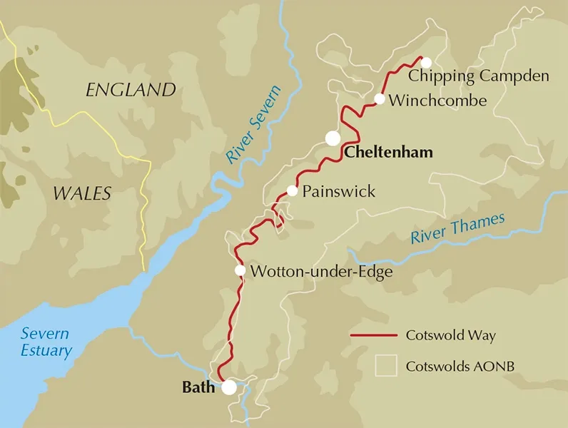
Guidebook to walking the 102 mile (163km) Cotswold Way National Trail between Chipping Campden and Bath, across the Cotswolds AONB. The guidebook – which includes both a guide to the route and a separate OS 1:25,000 map booklet – describes the route in both directions.
The route is described over 13 stages, each following the Cotswold escarpment, with dramatic and far-reaching views across the Severn Vale towards the Welsh hills, plunging down to visit honey-coloured villages, old market towns and the elegant and historic city of Bath. The longest of the 13 stages is 10 miles, the shortest 6 miles: these are dictated by the existence of overnight accommodation. For the determined, the trail can be walked in as little as five days.
The Cotswold Way offers a wonderful walker’s landscape, featuring beautiful woodland, pretty cottages and ancient battlefields. The route can be walked all year round, and is suitable for walkers of all abilities. The stage-by-stage route description is accompanied by maps at a scale of 1:100,000 (1cm to 1 mile) and full colour photographs. The guidebook also includes a map booklet showing the full route on 1:25,000 OS map extracts.
A trek planner gives at a glance information about facilities, public transport and accommodation available along the way, and there is plenty of background information on local geology, wildlife and history.
- Activities
Long-distance walking, trekking, eating and drinking - Seasons
Can be walked all year round: accommodation is scarce during Cheltenham Festival (March) and Badminton Horse Trials (late April/May) - Centres
Chipping Campden, Cheltenham, Gloucester, Stroud, Bath - Difficulty
The Cotswold Way is a waymarked lowland walk suitable for all abilities: suggested day sections are in the region of 6-10 miles (10-16km) - Must See
Hailes Abbey, Belas Knap, Crickley Hill, Haresfield Beacon, Sudley Castle, Broadway, views of Kelston Round Hill, roman baths (Bath)