Understanding Contours
King of the Hill Contours Test
Understanding contours
Understanding the shape of the land by looking at a map is a very useful skill and can be essential if you’re going to be walking in mountainous terrain. The height and shape of the land is shown on a map using ‘contour lines’. These lines appear as thin orange or brown lines with numbers on them. The number tells you the height above sea level of that line.
A contour line is drawn between points of the same height, so any single contour line will be at the same height all the way along its length. The height difference between separate contour lines is normally 5 meters, but it will be 10 meters in very hilly or mountainous areas with thick lines at 50 meter intervals. The map key will tell you the contour interval used.

The picture shown illustrates how a landscape can be converted into contour lines on a map. An easy way to understand and visualise contour lines is to think of them as high tide lines that would be left by the sea. As the water level drops it would leave a line every 10 meters on the landscape. These marks would be contour lines.
Being able to visualise the shape of the landscape by looking at the contour lines of a map is a very useful skill that can be developed with practice. It will allow you to choose the best route for your journey. When reading contour lines on a map it’s helpful to remember the numbering on them reads uphill. It might be useful to imagine that to read contour line numbers you have to be stood at the bottom of the hill looking up it, otherwise the numbers would be upside down. Other useful things to look out for when reading contour lines are rivers, which usually flow into valleys, or areas with very few contour lines, which will be flat.
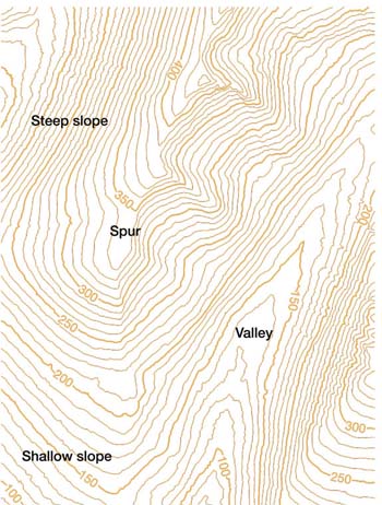
The picture below shows how contour lines can be used on maps to describe different landscapes. Even though all the lines look similar at first, they are describing very different landscape features. The closer together the contour lines, the steeper the slope of the hill. If a hill is very steep the contour lines might even merge into each other.
A spur is a ‘V’-shaped hill that juts out. A simple way to tell a valley from a spur when looking at contour lines is to remember that if the ‘V’ points uphill it’s a valley, if it points downhill it’s a spur.

Route elevation
Using contour lines you can calculate the elevation of your route, or height of travel. This is useful because you can add the uphill distance to the length of your route to get a more accurate estimate of the total distance you’ll go. For example, if you measure your route as being 2 km, and the difference between the contours along the way is 500 m, your actual distance is 2.5 km.
The best way to get to know about contours is to take a map with you when you’re walking, running or cycling and see if you can spot different landforms and what their contour patterns are. You can match the contour lines on Ordnance Survey maps to what you can see on the ground and practice recognising some of the classic contour shapes.
Ready to take the test?
