Reading Grid References
How To Read Ordnance Survey National Grid References
National Grid references are used to accurately pinpoint your location on an Ordnance Survey map. A series of faint blue lines on every map makes up a numbered grid that is used to create the National Grid reference. This is a simple way of finding points and places on a map, to give to others as a meeting location or to quote if you get into trouble and need to specify exactly where you are.
You may find a variety of terms used to describe National Grid references, such as ‘OS grid ref’, ‘grid reference’, ‘OS map ref’ or simply just ‘map reference’. While the correct term for these is ‘National Grid reference’, these terms all mean the same thing; however, as we’ll see, grid references can be given in a number of different formats.
The National Grid
Before we look at what the grid reference numbers mean, it’s important to understand the wider picture of the National Grid.
Ordnance Survey divides Great Britain into 100 km by 100 km squares, each with a two-letter code. The two-letter codes can be found printed in faint-blue capitals on Ordnance Survey maps and can also be found in the map key.
The first letter, for example ‘S’, denotes 500 km by 500 km squares and this is subdivided into 25 squares that are 100 km by 100 km within it, making ‘ST’, ‘SU’, ‘SO’ and so on.
There are four main first letters: ‘S’, ‘T’, ‘N’ and ‘H’ covering Great Britain, plus an ‘O’ square covering a tiny part of North Yorkshire that is usually below tide.
A unique National Grid reference should have this two-letter descriptor followed by the grid reference numbers within that square.
National Grid reference numbers
The numbers going across the map from left to right are called eastings, and go up in value eastwards, and the numbers going up the map from bottom to top are called northings, because they go up in a northward direction.
There are two main types of grid reference:
- four-figure grid reference, such as ‘19 45’, indicates a 1 km by 1 km square on the map; and
- six-figure grid reference, such as ‘192 454’, indicates a 100 m by 100 m square on the map.
Sometimes you may also come across:
- eight-figure grid reference, such as ‘1926 4548’, indicates a 10 m by 10 m square on the map; and
- ten-figure grid reference, such as ‘19267 45487’, indicates a 1 m by 1 m square on the map
In practice, it’s the six-digit grid reference number that is most commonly used, although the more digits used gives you a more precise location. GPS devices often specify at least eight-digit grid reference numbers.
Four-figure grid references
When giving a four-figure grid reference, you should always give the eastings number first and the northings number second, very much like when giving the reading of a graph in school, where you give the x coordinate first followed by the y.
An easy way to remember this is that to get the first number, you go along the corridor (horizontal, x axis, eastings) and then up the stairs (vertical, y axis, northings).
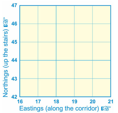
For example, the number 2 in the diagram below is square 19 across and square 45 up and therefore, the four-figure grid reference is ‘1945’.
The numbered squares on the diagram above have the following four-figure grid references:
1 = 18 45
2 = 19 45
3 = 18 44
4 = 19 44
Six-figure map references
To get the six-figure grid reference, you have to imagine that the four-figure square is further divided up into tenths.
In the example below, the grey box is in the four-figure grid reference square ‘18 44’, but more accurately it is 7 tenths across and 8 tenths up within that larger grid square, therefore the six-figure map reference is ‘187 448’.

The shapes on the diagram above have the following six-figure grid references:
Grey square – 187 448
Red dot – 185 443
To be sure there is no doubt or confusion about which National Grid you’re referring, when you quote the six-figure grid reference you should put the two letters of the area you are in before the numbers.
For example, you may be at grid reference ‘509 582’ in south-west Scotland. The complete grid reference you should quote would be ‘NX 509 582’ (without the letters the numeric reference would be repeated in every 100 km square).
Using compass romer lines
The romer lines marked on the base plate of most compasses can help you to get a more accurate grid reference. You choose the scale of the map you’re using and then move the compass base plate over the map to show the tenths within a map square. This is more accurate than guessing the tenth gradations within a square
Variations of grid references
In addition to the standard four, six and ten-digit formats, you may also come across several other ways that National Grid references can be quoted. For example, the summit of Snowdon’s grid reference is ‘SH 609 543’, but this may also be referred to as:
- An abbreviated number where the two National Grid letters are omitted, usually used if the context of the grid reference is obvious – ‘609 543’ or ‘609543’ on OS Landranger Map 115. People may also use this style to quote a reference for a place that is local to you.
- The full ten-digit grid reference with National Grid letter – ‘SH 60989 54379’ or without letters ‘60989 54379’ – the most accurate grid reference. Note that these longer grid references are hardly discernible at popular leisure map scales.
- With preceding numbers identifying the Ordnance Survey map sheet number – ‘17/609543’ for OS Explorer Map OL17 or ‘115/609543’ for OS Landranger Map sheet 115.
Latitude and longitude
Using latitude and longitude is a more accurate method of pinpointing the exact location of a very specific place on the earth’s surface and is commonly used by satellite positioning systems and GPS devices. Latitude specifies the north-south position of a point and longitude the east-west position.
You may come across the abbreviated version of the terms ‘lat-long’. Latitude and longitude references look like this: ‘50.855226 -1.402772’ and they are quite different to the grid references commonly used for determining points on an Ordnance Survey map.